Сурет:Map of Ancient Rome 271 AD.svg

Size of this PNG preview of this SVG file: 800 × 473 пиксел. Басқа ажыратылымдықтар: 320 × 189 пиксел | 640 × 379 пиксел | 1024 × 606 пиксел | 1280 × 757 пиксел | 2560 × 1515 пиксел | 2050 × 1213 пиксел.
Түпнұсқа файл (SVG файлы, кесімді 2050 × 1213 (пиксел) нүкте, файл өлшемі: 207 КБ)
| Бұл файл Wikimedia Commons? жобасынан, сондықтан басқа жобаларда да қолдануы мүмкін. Commons ашық лицензиялы медиа файл қоры. Сіз жобаға көмектесе аласыз. |
Ортаққордан қарау |
Түйін
| Сипаттамасы |
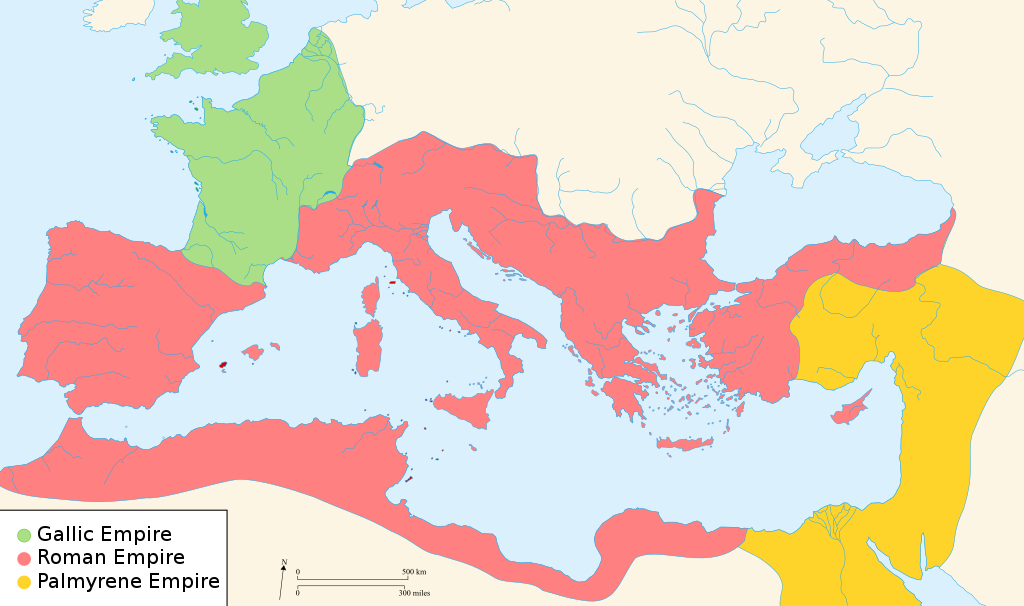
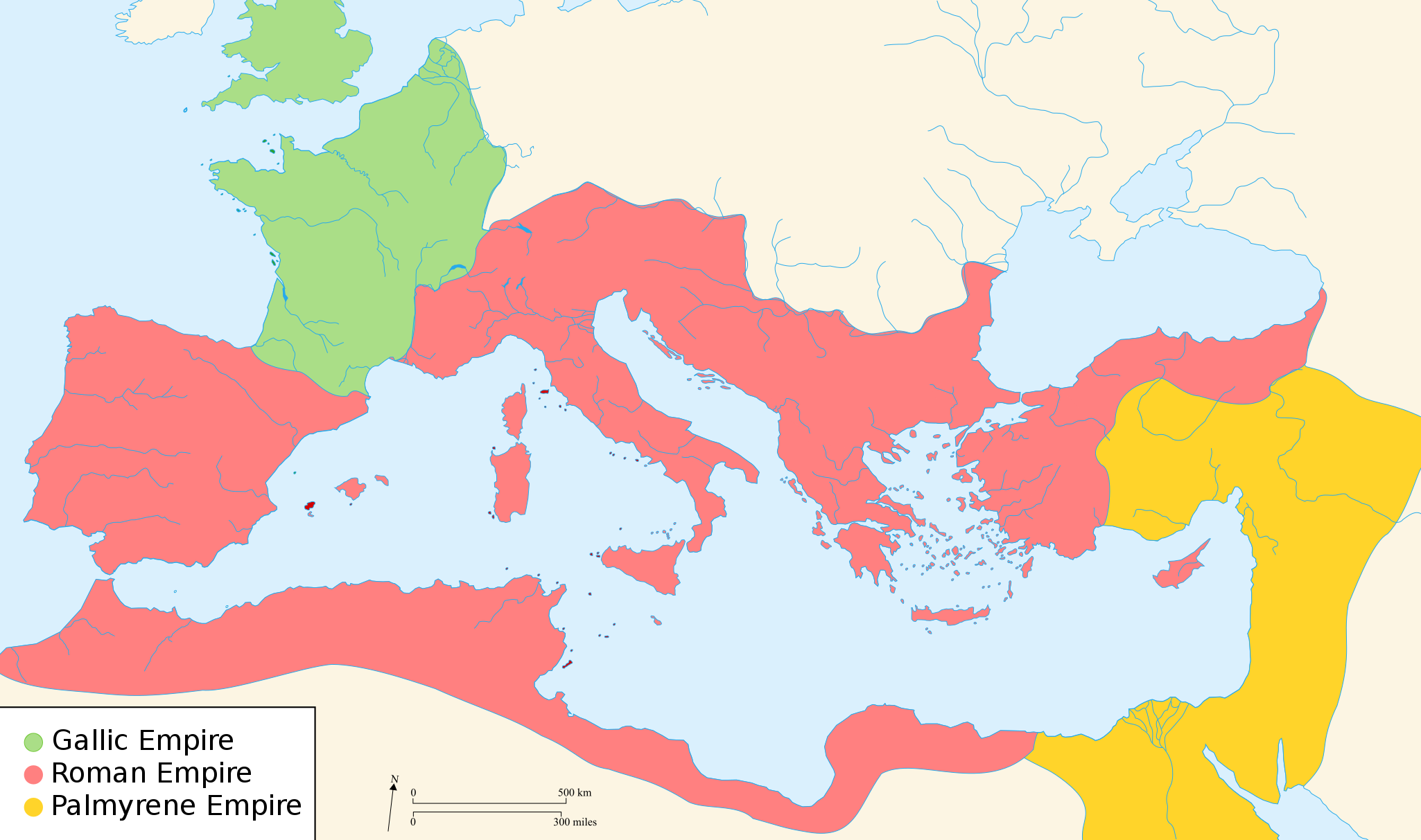
English: Map of the Roman Empire around the year of the consulship of Aurelianus and Bassus (271 AD), with the break away Gallic Empire in the West and the Palmyrene Empire in the East. |
||
| Күні | (UTC) | ||
| Көзі | |||
| Авторы |
|
||
| Рұқсат (Бұл файлды қайта қолдану) |
Мен бұл туындының авторымын, келесі лицензия аясында бұны жариялаймын:
Бұл файл Creative Commons Attribution-Share Alike 2.5 Generic, 2.0 Generic and 1.0 Generic лицензиялары бойынша қолжетімді.
Өз қалауыңызбен лицензияны таңдауыңызға болады. |
||
| Басқа нұсқалары |
[]
|


.svg)


|
This SVG file contains embedded text that can be translated into your language, using any capable SVG editor, text editor or the SVG Translate tool. For more information see: About translating SVG files. |
Лицензиялау

|
Бұл файлды GNU Free Documentation License лицензиясының 1.2 нұсқасы бойынша немесе ескі Ашық бағдарламалық жасақтаушы қорымен жарияланған нұсқасының шарттарына сәйкес көшірмесін алуға, таратуға және/немесе өзгертуге болады. Лицензия көшірмесі GNU Free Documentation License деп аталынған бөлімде көрсетілген. Subject to disclaimers. |
Тұпнұсқа жүктеу журналы
The original description page was here. All following user names refer to en.wikipedia.
- 2007-11-07 02:47 Justinian43 524×377×8 (26490 bytes) The Mediterranean by 271 A.D -The [[Roman Empire]]. -The breakaway [[Gallic Empire]]. -The breakaway [[Palmyrene Empire]].
- derivative work: Pomalee (talk)
other_versions=Derivative works of this file: Map of Ancient Rome 271 AD-sr.svg Permission= GNU Free Documentation License, Version 1.2, Creative Commons Attribution-ShareAlike license versions 3.0, 2.5, 2.0, and 1.0
- Romanworld271AD.jpg: User:Justinian43, uploaded by User:El_bes
| This is a retouched picture, which means that it has been digitally altered from its original version. Modifications: Used "Blank_map_of_South_Europe_and_North_Africa.svg" to refashion "Romanworld271.jpg". The original can be viewed here: Romanworld271AD.jpg:
|

|
Бұл файлды GNU Free Documentation License лицензиясының 1.2 нұсқасы бойынша немесе ескі Ашық бағдарламалық жасақтаушы қорымен жарияланған нұсқасының шарттарына сәйкес көшірмесін алуға, таратуға және/немесе өзгертуге болады. Лицензия көшірмесі GNU Free Documentation License деп аталынған бөлімде көрсетілген. |
| Бұл файл Creative Commons Attribution-Share Alike 3.0 Unported лицензиясы бойынша қолжетімді. | ||
| ||
| Лицензияландырудың бұл қасиеті осы файлға GFDL лицензиясының жаңартылуының бір бөлігі ретінде енгізілген. |
Тұпнұсқа жүктеу журналы
This image is a derivative work of the following images:
- File:Blank_map_of_South_Europe_and_North_Africa.svg licensed with Cc-by-sa-2.5,2.0,1.0, GFDL
- 2007-08-09T20:26:49Z Historicair 2050x1213 (1260388 Bytes)
- 2007-08-09T16:12:00Z Historicair 2050x1213 (351130 Bytes) {{Improving}} {{Information |Description={{fr}}Carte vierge de l'Europe du Sud et du Bassin Méditerranée dans l'Antiquité {{en}}Blank map of South Europe and North Africa at Antic period |Source=Own work + [[Image:Blank map of South Europe and North Africa.svg]] by myself
- File:Romanworld271AD.jpg licensed with GFDL-en
- 2007-11-20T15:23:56Z El bes 524x377 (26490 Bytes) {{Information |Description= The Roman Empire around the year 271 AD, with the break awai Gallic Empire in the West |Source= http://en.wikipedia.org/wiki/Image:Romanworld271AD.JPG |Date= November 20th, 2007 |Author= [[http://e
Uploaded with derivativeFX
Файл тарихы
Файл сол кезде қалай көрінгенін көру үшін күн/уақыт дегенге басыңыз.
| Күн/Уақыт | Нобай | Өлшемдер | Қатысушы | Пікір | |
|---|---|---|---|---|---|
| қазіргі | 02:07, 2022 ж. наурыздың 21 | | 2050 × 1213 (207 КБ) | Leptictidium | File uploaded using svgtranslate tool (https://svgtranslate.toolforge.org/). Added translation for ca. |
| 10:06, 2018 ж. тамыздың 24 |  | 2050 × 1213 (207 КБ) | Ras67 | frame removed | |
| 20:14, 2011 ж. желтоқсанның 18 |  | 2050 × 1213 (385 КБ) | Wanwa | more pleasant for eyesight colors | |
| 02:39, 2010 ж. тамыздың 28 |  | 2050 × 1213 (384 КБ) | Cplakidas | Corrections: the Agri Decumates beyond the Rhine had been abandoned already in 263, the Provence and Spain had been recovered by Rome in 269, and in 271, Zenobia controlled Asia Minor as far as Ancara at least | |
| 10:30, 2009 ж. ақпанның 26 |  | 2050 × 1213 (396 КБ) | Pomalee | Removed text labels from their paths and created a key. | |
| 09:36, 2009 ж. ақпанның 26 |  | 2050 × 1213 (393 КБ) | Pomalee | Changed the "Palmyran" label to "Palmyrene" | |
| 09:15, 2009 ж. ақпанның 26 |  | 2050 × 1213 (393 КБ) | Pomalee | {{Information |Description={{en}}Map of the Roman Empire around the year 271 AD, with the break away Gallic Empire in the West and the Palmyric Empire in the East. |Source=*File:Map_of_the_Ancient_Rome_at_Caesar_time-fr.svg *[[:File:Romanworld271AD. |
Файл қолданылуы
Бұл файлды мына 2 бет қолданады:
Глобалды файл қолданылуы
Бұл файл келесі басқа уикилерде қолданылады:
- af.wikipedia.org жобасында қолданылуы
- als.wikipedia.org жобасында қолданылуы
- ar.wikipedia.org жобасында қолданылуы
- azb.wikipedia.org жобасында қолданылуы
- az.wikipedia.org жобасында қолданылуы
- be-tarask.wikipedia.org жобасында қолданылуы
- be.wikipedia.org жобасында қолданылуы
- ca.wikipedia.org жобасында қолданылуы
- cs.wikipedia.org жобасында қолданылуы
- cy.wikipedia.org жобасында қолданылуы
- de.wikipedia.org жобасында қолданылуы
- el.wikipedia.org жобасында қолданылуы
- en.wikipedia.org жобасында қолданылуы
- 271
- Aurelian
- Claudius Gothicus
- Crisis of the Third Century
- Outline of ancient Rome
- Western Roman Empire
- Tetricus I
- Ancient Rome
- Late Latin
- Fall of the Western Roman Empire
- List of revolutions and rebellions
- Ledringhem
- List of Roman external wars and battles
- User:ChazCAESAR/sandbox
- User:Kazkaskazkasako/Books/History
- Classical Anatolia
Бұл файлдың глобалды қолданылуын көбірек көру.