Сурет:Federal subjects of Russia by population dencity.svg

Size of this PNG preview of this SVG file: 800 × 434 пиксел. Басқа ажыратылымдықтар: 320 × 173 пиксел | 640 × 347 пиксел | 1024 × 555 пиксел | 1280 × 694 пиксел | 2560 × 1388 пиксел | 5000 × 2710 пиксел.
Түпнұсқа файл (SVG файлы, кесімді 5000 × 2710 (пиксел) нүкте, файл өлшемі: 240 КБ)
| Бұл файл Wikimedia Commons? жобасынан, сондықтан басқа жобаларда да қолдануы мүмкін. Commons ашық лицензиялы медиа файл қоры. Сіз жобаға көмектесе аласыз. |
Ортаққордан қарау |
Crimea is Ukraine

|
The boundaries on this map show the de facto situation. This is just one of several different views on the subject (see COM:NPOV). |
Түйін
| Сипаттамасы |
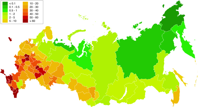
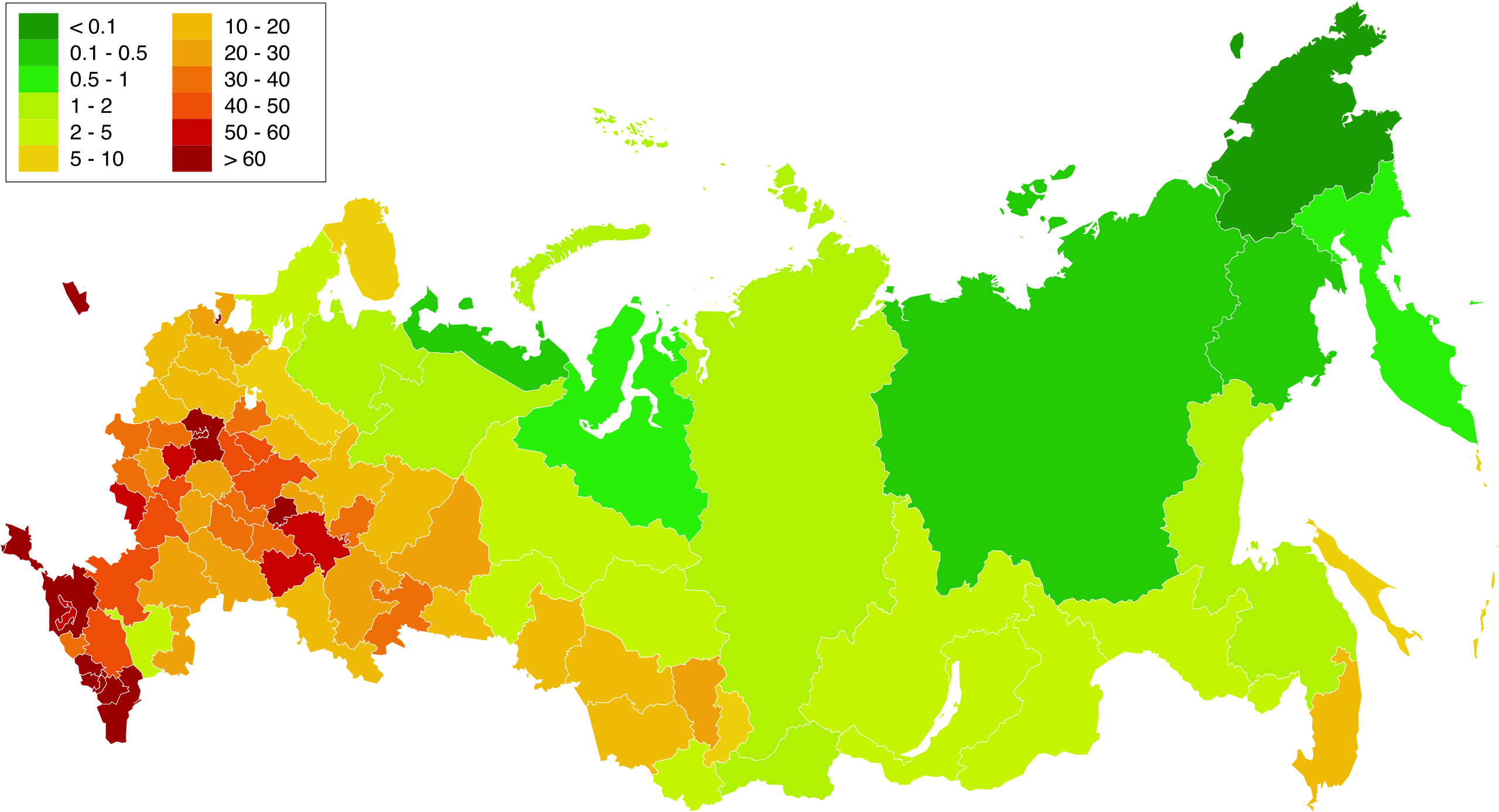
English: Map of population density in the subjects of the Russian Federation. The population density of Arkhangelsk Oblast and Tyumen Oblast was calculated together with the population and area of the respective Autonomous Okrugs belonging to them.
Русский: Карта плотности населения в субъектах Российской Федерации. При расчёте плотностей населения Архангельской и Тюменской области учитывались площади и населения входящих в них автономных округов. |
| Күні | 1.02.2010 20:39:08 MSK |
| Көзі | Russia - blank map (2009-01).svg |
| Авторы | Өзімнің туындым. Original uploader was Алексей Глушков at ru.wikipedia |
| Басқа нұсқалары |
Other views related to this image
|

.svg)
Лицензиялау
| I, the copyright holder of this work, release this work into the public domain. This applies worldwide. In some countries this may not be legally possible; if so: I grant anyone the right to use this work for any purpose, without any conditions, unless such conditions are required by law. |
Файл тарихы
Файл сол кезде қалай көрінгенін көру үшін күн/уақыт дегенге басыңыз.
| Күн/Уақыт | Нобай | Өлшемдер | Қатысушы | Пікір | |
|---|---|---|---|---|---|
| қазіргі | 21:58, 2019 ж. наурыздың 20 | | 5000 × 2710 (240 КБ) | Gajmar | Kaluga Oblast |
| 01:46, 2019 ж. наурыздың 20 |  | 5000 × 2710 (240 КБ) | Gajmar | new colour scheme | |
| 01:17, 2019 ж. наурыздың 20 |  | 5000 × 2710 (236 КБ) | Gajmar | update (01.01.2019) | |
| 20:39, 2013 ж. наурыздың 3 |  | 1650 × 1000 (141 КБ) | Gajmar | 1.01.2013 | |
| 21:53, 2011 ж. мамырдың 28 |  | 1650 × 1000 (140 КБ) | Gajmar | Update the data according to Russian census of 2010 (as of October 14). Indications of population density changed in Karachay-Cherkess Republic, Republic of Mari El, Leningrad Oblast and the Jewish Autonomous Oblast. / Обновление данных с | |
| 23:22, 2010 ж. ақпанның 1 |  | 1650 × 1000 (109 КБ) | Алексей Глушков | {{Information |Description={{en|1=Population density map in subjects of the Russian Federation. At calculation of population density Arkhangelsk and the Tyumen region the areas and the population of autonomous regions entering into them were considered.}} |
Файл қолданылуы
Бұл файлды мына бет қолданады:
Глобалды файл қолданылуы
Бұл файл келесі басқа уикилерде қолданылады:
- af.wikipedia.org жобасында қолданылуы
- ar.wikipedia.org жобасында қолданылуы
- az.wikipedia.org жобасында қолданылуы
- bg.wikipedia.org жобасында қолданылуы
- de.wikipedia.org жобасында қолданылуы
- es.wikipedia.org жобасында қолданылуы
- eu.wikipedia.org жобасында қолданылуы
- fa.wikipedia.org жобасында қолданылуы
- hu.wikipedia.org жобасында қолданылуы
- pnb.wikipedia.org жобасында қолданылуы
- ps.wikipedia.org жобасында қолданылуы
- ru.wikipedia.org жобасында қолданылуы
- te.wikipedia.org жобасында қолданылуы
- zh.wikipedia.org жобасында қолданылуы