Сурет:Lage des Muldentalkreises in Deutschland.png
Жоғарырақ ажыратымдылық жоқ.
Lage_des_Muldentalkreises_in_Deutschland.png (176 × 234 пиксел, файл өлшемі: 4 КБ, MIME түрі: image/png)
| Бұл файл Wikimedia Commons? жобасынан, сондықтан басқа жобаларда да қолдануы мүмкін. Commons ашық лицензиялы медиа файл қоры. Сіз жобаға көмектесе аласыз. |
Ортаққордан қарау |
Түйін
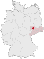
Karte erstellt auf der Grundlage der opengeodb.de-Umrisse.
Moved from de.wikipedia.org, first uploaded by de:Benutzer:Geograv.
Лицензиялау
This image was generated with OpenGeoDB. The information there is placed in the public domain, images generated from OpenGeoDB are derivative works without passing the threshold of creativity, they are therefore also public domain.
| This work is ineligible for copyright and therefore in the public domain because it consists entirely of information that is common property and contains no original authorship. |
Файл тарихы
Файл сол кезде қалай көрінгенін көру үшін күн/уақыт дегенге басыңыз.
| Күн/Уақыт | Нобай | Өлшемдер | Қатысушы | Пікір | |
|---|---|---|---|---|---|
| қазіргі | 03:22, 2006 ж. маусымның 1 | | 176 × 234 (4 КБ) | Rauenstein | == Summary == Karte erstellt auf der Grundlage der opengeodb.de-Umrisse. Moved from de.wikipedia.org, first uploaded by de:Benutzer:Geograv. == License == {{GFDL-OpenGeoDB}} Category:Maps of Saxony |
Файл қолданылуы
Бұл файлды мына бет қолданады:
Глобалды файл қолданылуы
Бұл файл келесі басқа уикилерде қолданылады:
- de.wikipedia.org жобасында қолданылуы
- es.wikipedia.org жобасында қолданылуы
- fr.wikipedia.org жобасында қолданылуы
- hy.wikipedia.org жобасында қолданылуы
- it.wikipedia.org жобасында қолданылуы
- ka.wikipedia.org жобасында қолданылуы
- nl.wikipedia.org жобасында қолданылуы
- pl.wikipedia.org жобасында қолданылуы
- pt.wikipedia.org жобасында қолданылуы
- uk.wikipedia.org жобасында қолданылуы