Сурет:Lake Athabasca, Canada.jpg

Бұл алдын ала көрудің өлшемі: 800 × 338 пиксел. Басқа ажыратылымдықтар: 320 × 135 пиксел | 640 × 270 пиксел | 1156 × 488 пиксел.
Түпнұсқа файл (1156 × 488 пиксел, файл өлшемі: 173 КБ, MIME түрі: image/jpeg)
| Бұл файл Wikimedia Commons? жобасынан, сондықтан басқа жобаларда да қолдануы мүмкін. Commons ашық лицензиялы медиа файл қоры. Сіз жобаға көмектесе аласыз. |
Ортаққордан қарау |
Түйін
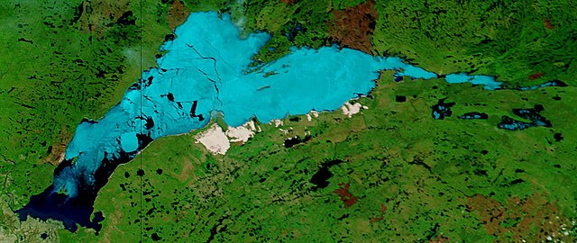
| Сипаттамасы | Lake Athabasca, Canada. Lake Athabasca straddles the border between Alberta (west) and Saskatchewan (east) - the black line. In the false-color image, vegetation is green, water is dark blue, and ice (or snow) is light blue. |
| Күні | Visualization Date: 2002-06-18 |
| Көзі | Visible Earth, NASA (extract) |
| Авторы | Jacques Descloitres, MODIS Land Rapid Response Team, NASA/GSFC |
Cropped from the original 4800 x 3600 JPEG (4.4MB) image.
Лицензиялау
| This file is in the public domain in the United States because it was solely created by NASA. NASA copyright policy states that "NASA material is not protected by copyright unless noted". (See Template:PD-USGov, NASA copyright policy page or JPL Image Use Policy.) | ||
 |
Warnings:
|
Файл тарихы
Файл сол кезде қалай көрінгенін көру үшін күн/уақыт дегенге басыңыз.
| Күн/Уақыт | Нобай | Өлшемдер | Қатысушы | Пікір | |
|---|---|---|---|---|---|
| қазіргі | 16:37, 2006 ж. тамыздың 18 | | 1156 × 488 (173 КБ) | Feydey | {{Information |Description= Lake Athabasca, Canada. Lake Athabasca straddles the border between Alberta (west) and Saskatchewan (east) - the black line. In the false-color image, vegetation is green, water is dark blue, and ice (or snow) is light blue. |S |
Файл қолданылуы
Бұл файлды мына бет қолданады:
Глобалды файл қолданылуы
Бұл файл келесі басқа уикилерде қолданылады:
- af.wikipedia.org жобасында қолданылуы
- ar.wikipedia.org жобасында қолданылуы
- arz.wikipedia.org жобасында қолданылуы
- be.wikipedia.org жобасында қолданылуы
- bg.wikipedia.org жобасында қолданылуы
- bn.wikipedia.org жобасында қолданылуы
- bs.wikipedia.org жобасында қолданылуы
- ca.wikipedia.org жобасында қолданылуы
- ceb.wikipedia.org жобасында қолданылуы
- cv.wikipedia.org жобасында қолданылуы
- cy.wikipedia.org жобасында қолданылуы
- da.wikipedia.org жобасында қолданылуы
- el.wikipedia.org жобасында қолданылуы
- en.wikipedia.org жобасында қолданылуы
- eo.wikipedia.org жобасында қолданылуы
- es.wikipedia.org жобасында қолданылуы
- eu.wikipedia.org жобасында қолданылуы
- fa.wikipedia.org жобасында қолданылуы
- frr.wikipedia.org жобасында қолданылуы
- fr.wikipedia.org жобасында қолданылуы
- fy.wikipedia.org жобасында қолданылуы
- hu.wikipedia.org жобасында қолданылуы
- hy.wikipedia.org жобасында қолданылуы
- id.wikipedia.org жобасында қолданылуы
- incubator.wikimedia.org жобасында қолданылуы
- it.wikipedia.org жобасында қолданылуы
- ka.wikipedia.org жобасында қолданылуы
- ky.wikipedia.org жобасында қолданылуы
- lt.wikipedia.org жобасында қолданылуы
- lv.wikipedia.org жобасында қолданылуы
- nl.wikipedia.org жобасында қолданылуы
- no.wikipedia.org жобасында қолданылуы
- pl.wikipedia.org жобасында қолданылуы
- pl.wiktionary.org жобасында қолданылуы
- pnb.wikipedia.org жобасында қолданылуы
- pt.wikipedia.org жобасында қолданылуы
- ro.wikipedia.org жобасында қолданылуы
- ru.wikipedia.org жобасында қолданылуы
- sv.wikipedia.org жобасында қолданылуы
Бұл файлдың глобалды қолданылуын көбірек көру.