Сурет:Oceanias Regions.png
Жоғарырақ ажыратымдылық жоқ.
Oceanias_Regions.png (552 × 350 пиксел, файл өлшемі: 20 КБ, MIME түрі: image/png)
| Бұл файл Wikimedia Commons? жобасынан, сондықтан басқа жобаларда да қолдануы мүмкін. Commons ашық лицензиялы медиа файл қоры. Сіз жобаға көмектесе аласыз. |
Ортаққордан қарау |

|
This locator map image could be re-created using vector graphics as an SVG file. This has several advantages; see Commons:Media for cleanup for more information. If an SVG form of this image is available, please upload it and afterwards replace this template with
{{vector version available|new image name}}.
It is recommended to name the SVG file “Oceanias Regions.svg”—then the template Vector version available (or Vva) does not need the new image name parameter. |
| Сипаттамасы |
Català: Regions d'Oceania.
Čeština: Regiony Oceánie.
Deutsch: Regionen Ozeaniens.
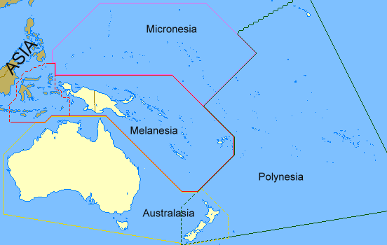
English: Regions of Oceania. Regions of Oceania: In its narrow usage Oceania refers to Polynesia (including New Zealand), Melanesia (including New Guinea) and Micronesia. In wider usage it includes Australia. It may also include the Malay archipelago. In uncommon usage it includes islands such as Japan and the Aleutian Islands.
Limburgs: Regio's van Oceanië.
Русский: Регионы Океании.
Саха тыла: Океания регионнара.
Svenska: Oceaniens regioner.
తెలుగు: ఓషియానియా ప్రాంతాలు.
Tiếng Việt: Các khu vực của châu Đại Dương. |
| Күні | 17 ақпан 2008 (original upload date) |
| Көзі | Transferred from en.wikipedia to Commons by Grillo using CommonsHelper. |
| Авторы | ASDFGH at ағылшын тілі Уикипедия |
Лицензиялау
| This work has been released into the public domain by its author, ASDFGH at ағылшын тілі Уикипедия. This applies worldwide. In some countries this may not be legally possible; if so: ASDFGH grants anyone the right to use this work for any purpose, without any conditions, unless such conditions are required by law. |
Тұпнұсқа жүктеу журналы
The original description page was here. All following user names refer to en.wikipedia.
- 2008-02-17 00:28 ASDFGH 552×350× (17433 bytes)
Файл тарихы
Файл сол кезде қалай көрінгенін көру үшін күн/уақыт дегенге басыңыз.
| Күн/Уақыт | Нобай | Өлшемдер | Қатысушы | Пікір | |
|---|---|---|---|---|---|
| қазіргі | 18:20, 2011 ж. қыркүйектің 18 | | 552 × 350 (20 КБ) | Maphobbyist | Map depicting continents according to plate tectonics. The Eastern Sunda Islands and the Moluccas are also part of the Asian tectonic plate. |
| 21:57, 2008 ж. қазанның 30 |  | 552 × 350 (17 КБ) | File Upload Bot (Magnus Manske) | {{BotMoveToCommons|en.wikipedia}} {{Information |Description={{en|''no original description''}} |Source=Transferred from [http://en.wikipedia.org en.wikipedia]; transferred to Commons by User:Grillo using [http://tools.wikimedia.de/~magnus/commonshel |
Файл қолданылуы
Бұл файлды мына бет қолданады:
Глобалды файл қолданылуы
Бұл файл келесі басқа уикилерде қолданылады:
- ast.wiktionary.org жобасында қолданылуы
- bn.wikipedia.org жобасында қолданылуы
- ca.wikipedia.org жобасында қолданылуы
- co.wikipedia.org жобасында қолданылуы
- cs.wikipedia.org жобасында қолданылуы
- cy.wiktionary.org жобасында қолданылуы
- da.wiktionary.org жобасында қолданылуы
- el.wiktionary.org жобасында қолданылуы
- en.wikipedia.org жобасында қолданылуы
- en.wiktionary.org жобасында қолданылуы
- fa.wikipedia.org жобасында қолданылуы
- fo.wikipedia.org жобасында қолданылуы
- fr.wikipedia.org жобасында қолданылуы
- gl.wikipedia.org жобасында қолданылуы
- hi.wikipedia.org жобасында қолданылуы
- ilo.wikipedia.org жобасында қолданылуы
- incubator.wikimedia.org жобасында қолданылуы
- ja.wikipedia.org жобасында қолданылуы
- ko.wikipedia.org жобасында қолданылуы
- la.wikipedia.org жобасында қолданылуы
- li.wikipedia.org жобасында қолданылуы
- lld.wikipedia.org жобасында қолданылуы
- lt.wikipedia.org жобасында қолданылуы
- mg.wikipedia.org жобасында қолданылуы
- my.wikipedia.org жобасында қолданылуы
- pa.wikipedia.org жобасында қолданылуы
- pnb.wikipedia.org жобасында қолданылуы
- ro.wikipedia.org жобасында қолданылуы
- sah.wikipedia.org жобасында қолданылуы
- si.wiktionary.org жобасында қолданылуы
- sk.wikipedia.org жобасында қолданылуы
- sv.wikipedia.org жобасында қолданылуы
- ta.wikipedia.org жобасында қолданылуы
- te.wikipedia.org жобасында қолданылуы
- th.wikipedia.org жобасында қолданылуы
- tr.wikipedia.org жобасында қолданылуы
- uk.wikipedia.org жобасында қолданылуы
- yo.wikipedia.org жобасында қолданылуы