Сурет:Orbits around earth scale diagram.svg

Size of this PNG preview of this SVG file: 600 × 600 пиксел. Басқа ажыратылымдықтар: 240 × 240 пиксел | 480 × 480 пиксел | 768 × 768 пиксел | 1024 × 1024 пиксел | 2048 × 2048 пиксел | 4300 × 4300 пиксел.
Түпнұсқа файл (SVG файлы, кесімді 4300 × 4300 (пиксел) нүкте, файл өлшемі: 5 КБ)
| Бұл файл Wikimedia Commons? жобасынан, сондықтан басқа жобаларда да қолдануы мүмкін. Commons ашық лицензиялы медиа файл қоры. Сіз жобаға көмектесе аласыз. |
Ортаққордан қарау |
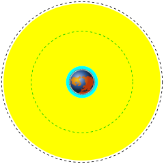
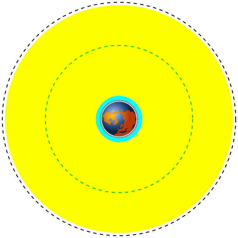
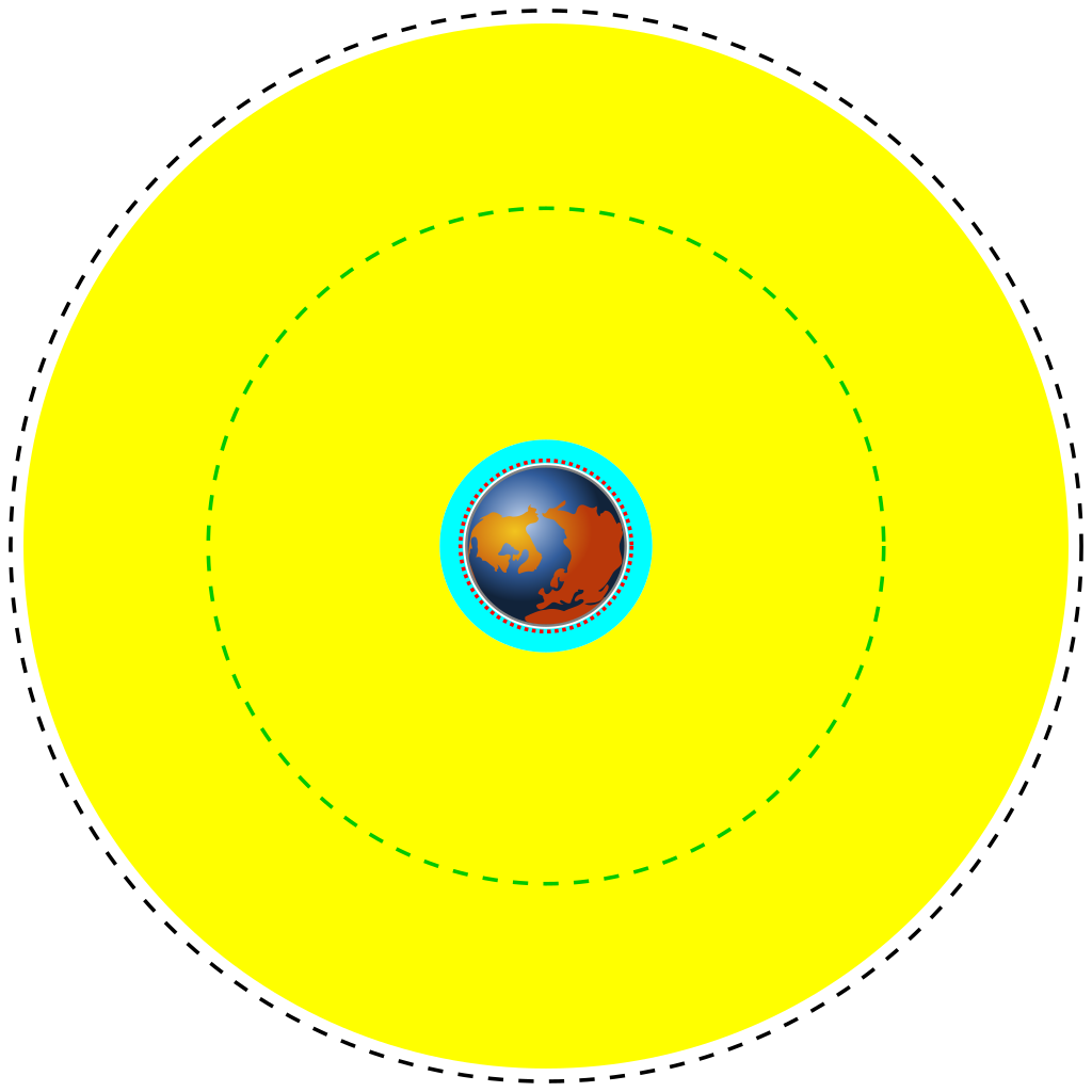
| English | Deutsch | Français | Marker | Distance above earth (km) | Distance from center of earth (km) |
|---|---|---|---|---|---|
| Earth | Erde | Terre | Blue/brown image | 0 | 6370 |
| Low Earth Orbit (LEO) | Low Earth Orbit | Orbite terrestre basse | Cyan area | 160 to 2,000 | 6,530 to 8,370 |
| Medium Earth Orbit (MEO) | Medium Earth Orbit | Orbite moyenne de la terre | Yellow area | 2,000 to 34,780 | 8,370 to 41,150 |
| International Space Station (ISS) | Internationale Raumstation | Station spatiale internationale | Red dotted line | 370 | 6,741 |
| Global Positioning System (GPS) satellites | Globales Positionsbestimmungssystem | Système de positionnement mondial | Green dash-dot line | 20,230 | 26,600 |
| Geostationary Orbit (GEO) | Geostationäre Umlaufbahn | Orbite géostationnaire | Black dashed line | 35,794 | 42,164 |
| Сипаттамасы |
English: A scale diagram showing earth and various orbits above it.
Deutsch: Skalendiagramm der Erde und verschiedener Umlaufbahnen.
Français : Diagramme échelle montrant la terre et des orbites. |
||
| Күні | |||
| Көзі | Created by Commons user Mike1024, Earth based on File:Worldmap northern.svg | ||
| Авторы | Image of earth: Gringer. Scale orbits: Mike1024 | ||
| Рұқсат (Бұл файлды қайта қолдану) |
This image is based on a public domain image (File:Worldmap northern.svg) and is released into the public domain.
|
12121
Файл тарихы
Файл сол кезде қалай көрінгенін көру үшін күн/уақыт дегенге басыңыз.
| Күн/Уақыт | Нобай | Өлшемдер | Қатысушы | Пікір | |
|---|---|---|---|---|---|
| қазіргі | 01:06, 2014 ж. наурыздың 31 | | 4300 × 4300 (5 КБ) | XZise | fixed rotation of Earth (is now looking from above) |
| 21:27, 2014 ж. наурыздың 30 |  | 4300 × 4300 (3 КБ) | XZise | manually rewritten from scratch thus dramatically reduced file size | |
| 05:19, 2008 ж. қаңтардың 17 |  | 3009 × 3009 (19 КБ) | Mike1024 | {| class="wikitable" style="text-align:center" |- ! English !! Deutsch !! Français !! Marker !! Distance above earth (km) |!!Distance from center of earth (km) |- ! Earth !! Erde !! Terre | Blue/brown image || 0 | |
Файл қолданылуы
Бұл файлды мына 2 бет қолданады:
Глобалды файл қолданылуы
Бұл файл келесі басқа уикилерде қолданылады:
- ar.wikipedia.org жобасында қолданылуы
- ast.wikipedia.org жобасында қолданылуы
- bn.wikipedia.org жобасында қолданылуы
- ca.wikipedia.org жобасында қолданылуы
- cs.wikipedia.org жобасында қолданылуы
- da.wikipedia.org жобасында қолданылуы
- de.wikipedia.org жобасында қолданылуы
- el.wikipedia.org жобасында қолданылуы
- en.wikipedia.org жобасында қолданылуы
- en.wikiversity.org жобасында қолданылуы
- eo.wikipedia.org жобасында қолданылуы
- es.wikipedia.org жобасында қолданылуы
- et.wikipedia.org жобасында қолданылуы
- eu.wikipedia.org жобасында қолданылуы
- fa.wikipedia.org жобасында қолданылуы
- fi.wikipedia.org жобасында қолданылуы
- fr.wikipedia.org жобасында қолданылуы
- gu.wikipedia.org жобасында қолданылуы
- he.wikipedia.org жобасында қолданылуы
- hi.wikipedia.org жобасында қолданылуы
- hr.wikipedia.org жобасында қолданылуы
Бұл файлдың глобалды қолданылуын көбірек көру.