Сурет:Portuguese colonial war map1.PNG
Жоғарырақ ажыратымдылық жоқ.
Portuguese_colonial_war_map1.PNG (360 × 392 пиксел, файл өлшемі: 12 КБ, MIME түрі: image/png)
| Бұл файл Wikimedia Commons? жобасынан, сондықтан басқа жобаларда да қолдануы мүмкін. Commons ашық лицензиялы медиа файл қоры. Сіз жобаға көмектесе аласыз. |
Ортаққордан қарау |

|
File:Portuguese colonial war blank map.svg is a vector version of this file. It should be used in place of this PNG file when not inferior.
File:Portuguese colonial war map1.PNG → File:Portuguese colonial war blank map.svg
For more information, see Help:SVG. |
 |
Түйін
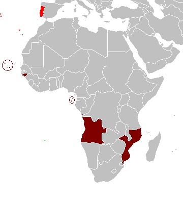
Map of the Portuguese colonies in Africa by the time of the Portuguese Colonial War (1961-1974).
Source
- English Wikipedia, uploaded by User:Mário
Revision history
12:19, 8 April 2006 . . Mário (Talk | contribs) . . 360×392 (12,409 bytes) (Map of the Portuguese colonies in Africa by the time of the Portuguese Colonial War (1961-1974).)
Лицензиялау
| I, the copyright holder of this work, release this work into the public domain. This applies worldwide. In some countries this may not be legally possible; if so: I grant anyone the right to use this work for any purpose, without any conditions, unless such conditions are required by law. |
Файл тарихы
Файл сол кезде қалай көрінгенін көру үшін күн/уақыт дегенге басыңыз.
| Күн/Уақыт | Нобай | Өлшемдер | Қатысушы | Пікір | |
|---|---|---|---|---|---|
| қазіргі | 15:17, 2008 ж. наурыздың 5 | | 360 × 392 (12 КБ) | The Ogre | Enhanced visualization |
| 00:51, 2007 ж. қарашаның 27 |  | 360 × 392 (12 КБ) | Hoshie | added Cabinda, updated base map | |
| 19:46, 2006 ж. тамыздың 12 |  | 360 × 392 (12 КБ) | Nuno Tavares | == Summary == Map of the Portuguese colonies in Africa by the time of the Portuguese Colonial War (1961-1974). ==Source== <pre> 12:19, 8 April 2006 . . Mário (Talk | contribs) . . 360×392 (12,409 bytes) (Map of the Portuguese colonies i |
Файл қолданылуы
Бұл файлға еш бет сілтемейді.
Глобалды файл қолданылуы
Бұл файл келесі басқа уикилерде қолданылады:
- de.wikipedia.org жобасында қолданылуы
- en.wikipedia.org жобасында қолданылуы
- fr.wikipedia.org жобасында қолданылуы
- ja.wikipedia.org жобасында қолданылуы