Сурет:USA Territorial Growth small.gif
Жоғарырақ ажыратымдылық жоқ.
USA_Territorial_Growth_small.gif (431 × 287 пиксел, файл өлшемі: 456 КБ, MIME түрі: image/gif, тұйық, 10 кадр, 30с)
| Бұл файл Wikimedia Commons? жобасынан, сондықтан басқа жобаларда да қолдануы мүмкін. Commons ашық лицензиялы медиа файл қоры. Сіз жобаға көмектесе аласыз. |
Ортаққордан қарау |

|
This file has been superseded by USA territorial growth.gif. It is recommended to use the other file. Please note that deleting superseded images requires consent.
|

|
Түйін
| Сипаттамасы |
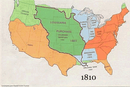
English: US territorial growth 1810–1920, based on the PD USGS maps in Category:Territorial growth maps of the United States.
See key below for explanation of colors.  |
||||||
| Көзі |
|
||||||
| Авторы |
|
||||||
| Басқа нұсқалары |
|
Лицензиялау
This image is in the public domain in the United States because it only contains materials that originally came from the United States Geological Survey, an agency of the United States Department of the Interior. For more information, see the official USGS copyright policy.
|
Файл тарихы
Файл сол кезде қалай көрінгенін көру үшін күн/уақыт дегенге басыңыз.
| Күн/Уақыт | Нобай | Өлшемдер | Қатысушы | Пікір | |
|---|---|---|---|---|---|
| қазіргі | 16:50, 2006 ж. мамырдың 30 | | 431 × 287 (456 КБ) | Roke~commonswiki | US territorial growth, based on the PD USGS maps in Category:USA Territorial Growth Maps Category: USA Territorial Growth Maps {{PD-USGov-USGS}} |
Файл қолданылуы
Бұл файлды мына бет қолданады:
Глобалды файл қолданылуы
Бұл файл келесі басқа уикилерде қолданылады:
- ar.wikipedia.org жобасында қолданылуы
- be-tarask.wikipedia.org жобасында қолданылуы
- be.wikipedia.org жобасында қолданылуы
- ca.wikipedia.org жобасында қолданылуы
- ckb.wikipedia.org жобасында қолданылуы
- da.wikipedia.org жобасында қолданылуы
- fr.wikipedia.org жобасында қолданылуы
- fy.wikipedia.org жобасында қолданылуы
- gcr.wikipedia.org жобасында қолданылуы
- hr.wikipedia.org жобасында қолданылуы
- id.wikipedia.org жобасында қолданылуы
- it.wikipedia.org жобасында қолданылуы
- jv.wikipedia.org жобасында қолданылуы
- ro.wikipedia.org жобасында қолданылуы
- sh.wikipedia.org жобасында қолданылуы
- sl.wikipedia.org жобасында қолданылуы
- sr.wikipedia.org жобасында қолданылуы
- tr.wikipedia.org жобасында қолданылуы
- uk.wikipedia.org жобасында қолданылуы