Сурет:1818 Pinkerton Map of the West Indies, Antilles, and Caribbean Sea - Geographicus - WestIndies2-pinkerton-1818.jpg
Бұл алдын ала көрудің өлшемі: 800 × 590 пиксел. Басқа ажыратылымдықтар: 320 × 236 пиксел | 640 × 472 пиксел | 1024 × 755 пиксел | 1280 × 943 пиксел | 2560 × 1887 пиксел | 5000 × 3685 пиксел.
Түпнұсқа файл (5000 × 3685 пиксел, файл өлшемі: 3,91 MB, MIME түрі: image/jpeg)
| Бұл файл Wikimedia Commons? жобасынан, сондықтан басқа жобаларда да қолдануы мүмкін. Commons ашық лицензиялы медиа файл қоры. Сіз жобаға көмектесе аласыз. |
Ортаққордан қарау |
| John Pinkerton: West Indies.
( |
|||||||||||||||||||||
|---|---|---|---|---|---|---|---|---|---|---|---|---|---|---|---|---|---|---|---|---|---|
| Әртіс |
|
||||||||||||||||||||
| Атауы |
West Indies. |
||||||||||||||||||||
| Сипаттамасы |
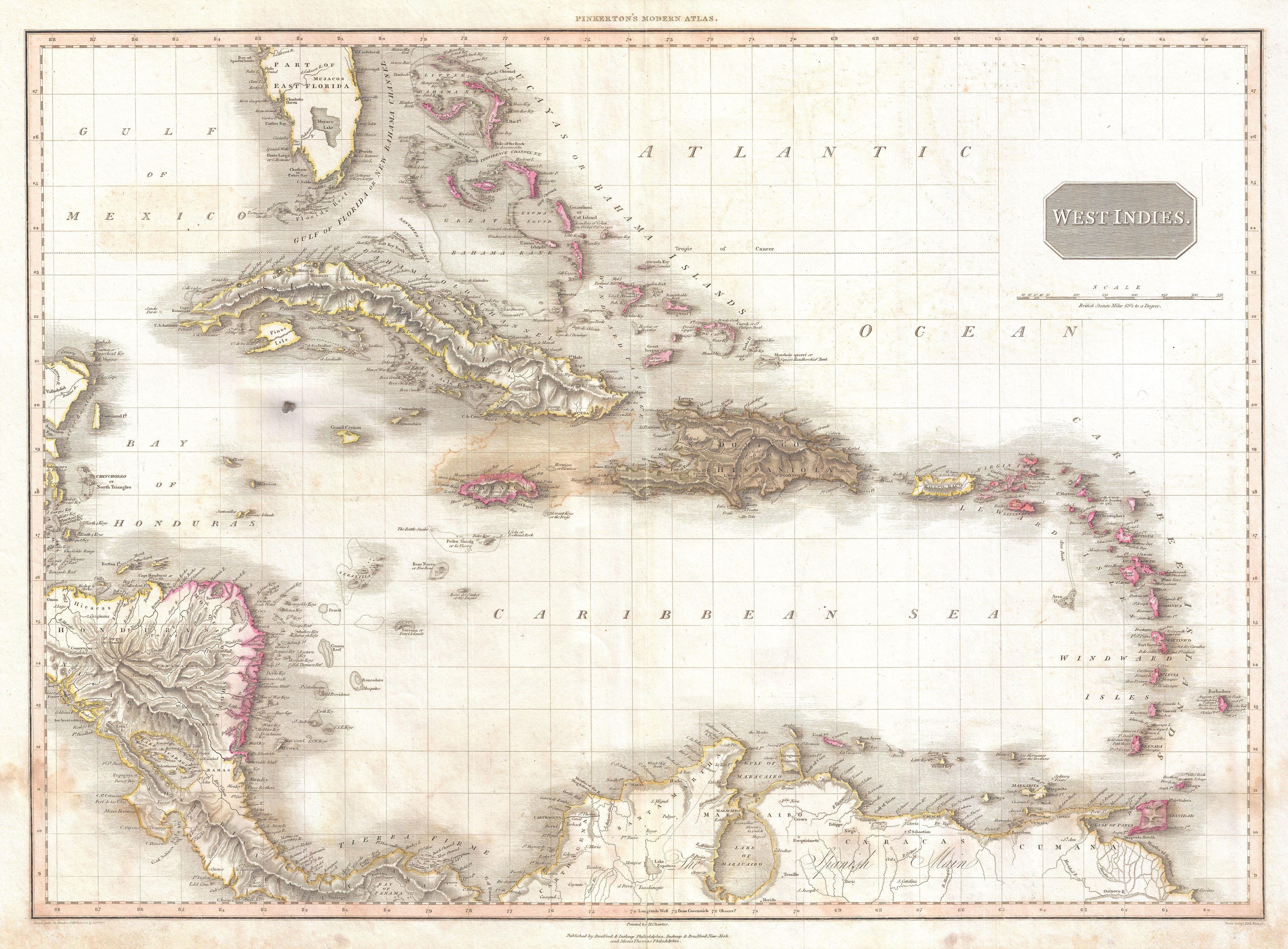
English: Extraordinary large format map of the West Indies published in 1818 by cartographer John Pinkerton. Centered on the island of Hispaniola or Santo Domingo, this map covers from the Bay of Honduras to the Windward Isles, and from Florida and the Bahamas south to Lake Maracaibo and the Spanish Main. Includes Cuba, Jamaica, Porto Rico, Hispaniola, the Bahamas, and southern Florida. In Florida there is a large inland lake, labeled Mayaco, which is no doubt an embryonic representation of Lake Okeechobee. Pinkerton offers extraordinary detail throughout noting both physical and political elements, including shoals, reefs, and other undersea dangers. Possibly the most attractive English map of the West Indies to appear in the early 19th century. Drawn by L. Herbert and engraved by Samuel Neele under the direction of John Pinkerton. The map comes from the scarce American edition of Pinkerton’s Modern Atlas, published by Thomas Dobson & Co. of Philadelphia in 1818. |
||||||||||||||||||||
| Күні | 1818 (undated) | ||||||||||||||||||||
| Өлшемдері | height: 21 in (53,3 cm);width: 28 in (71,1 cm) | ||||||||||||||||||||
| Өсім нөмері |
Geographicus link: WestIndies2-pinkerton-1818 |
||||||||||||||||||||
| Қайнары/Фотограф |
Pinkerton, J., A Modern Atlas, from the Lates and Best Authorities, Exhibiting the Various Divisions of the World with its chief Empires, Kingdoms, and States; in Sixty Maps, carefully reduced from the Larges and Most Authentic Sources. 1818, Philadelphia, Thomas Dobson Edition.
|
||||||||||||||||||||
| Рұқсат (Бұл файлды қайта қолдану) |
|
||||||||||||||||||||

See also
- Alternative map of early 1800s West Indies:

Файл тарихы
Файл сол кезде қалай көрінгенін көру үшін күн/уақыт дегенге басыңыз.
| Күн/Уақыт | Нобай | Өлшемдер | Қатысушы | Пікір | |
|---|---|---|---|---|---|
| қазіргі | 10:26, 2011 ж. наурыздың 23 | | 5000 × 3685 (3,91 MB) | BotMultichillT | {{subst:User:Multichill/Geographicus |link=http://www.geographicus.com/P/AntiqueMap/WestIndies2-pinkerton-1818 |product_name=1818 Pinkerton Map of the West Indies, Antilles, and Caribbean Sea |map_title=West Indies. |description=Extraordinary large format |
Файл қолданылуы
Бұл файлға еш бет сілтемейді.
Глобалды файл қолданылуы
Бұл файл келесі басқа уикилерде қолданылады:
- en.wikipedia.org жобасында қолданылуы
- es.wikipedia.org жобасында қолданылуы
- ja.wikipedia.org жобасында қолданылуы
- ru.wikipedia.org жобасында қолданылуы