Сурет:60m artificial fumarole at el tatio geothermal field.jpg

Түпнұсқа файл (900 × 595 пиксел, файл өлшемі: 294 КБ, MIME түрі: image/jpeg)
| Бұл файл Wikimedia Commons? жобасынан, сондықтан басқа жобаларда да қолдануы мүмкін. Commons ашық лицензиялы медиа файл қоры. Сіз жобаға көмектесе аласыз. |
Ортаққордан қарау |
Түйін
| Сипаттамасы |
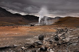
English: In 2008, the “Geortérmica del Norte” consortium - formed by Chilean state owned ENAP and Codelco mining companies in association with Italian Enel Green Power - began exploration in the "quebrada El Zoquete", near the El Tatio geothermal field in Chile's II Region, with the purpose of constructing a 40 MW geothermal plant. After months of exploration, an operating malfunction occurred in well No. 10 in September 2009, causing the eruption of a 60-m-high artificial fumarole which took away virtually all the pressure in the El Tatio complex. Although the company finally managed to close the well, damage was not limited to the visual. Ignorance of both guides and visitors - who were literally running all over the vents - caused extensive damage to the fragile mineral deposits, and the harm make take years, if not decades, to get undone. In fact, an earlier exploration attempt in the late sixties turned into disaster – even if only economically. |
| Күні | |
| Көзі | Өзімнің туындым |
| Авторы | Gerard Prins |
| Camera location | | View this and other nearby images on: OpenStreetMap |
|---|
Altitude: 4334.00 m
Лицензиялау
- Сіз келесі әрекеттерге еркінсіз:
- бөлісу – туындыны көшіру, тарату және тапсыру
- мазмұнын өзгерту – туындыны бейімдеу
- Келесі ережелерді сақтағанда:
- атрибуция – Авторлықты белгілеп, лицензияға сілтеме беріп, өзгеріс жасалғанын анықтауыңыз керек. Сіз мұны кез келген орынды жолмен істей аласыз, бірақ лицензиар сізді немесе қолдануыңызды мақұлдайтындай емес.
- бірдей шарттарда тарату – Материалды араластырсаңыз, түрлендірсеңіз немесе құрастырсаңыз, үлестеріңізді түпнұсқамен бірдей бірдей немесе үйлесімді лицензия бойынша таратуыңыз керек.

|
Бұл файлды GNU Free Documentation License лицензиясының 1.2 нұсқасы бойынша немесе ескі Ашық бағдарламалық жасақтаушы қорымен жарияланған нұсқасының шарттарына сәйкес көшірмесін алуға, таратуға және/немесе өзгертуге болады. Лицензия көшірмесі GNU Free Documentation License деп аталынған бөлімде көрсетілген. |
Файл тарихы
Файл сол кезде қалай көрінгенін көру үшін күн/уақыт дегенге басыңыз.
| Күн/Уақыт | Нобай | Өлшемдер | Қатысушы | Пікір | |
|---|---|---|---|---|---|
| қазіргі | 12:47, 2010 ж. ақпанның 23 | | 900 × 595 (294 КБ) | Gerard Prins | {{Information |Description={{en|1=A failed prospecting drill for geothermal exploitation by the “Geortérmica del Norte” consortium, formed by Chilean state owned ENAP and Codelco in association with Italian state owned ENEL, has caused an eco disaste |
Файл қолданылуы
Бұл файлды мына бет қолданады:
Глобалды файл қолданылуы
Бұл файл келесі басқа уикилерде қолданылады:
- ba.wikipedia.org жобасында қолданылуы
- en.wikipedia.org жобасында қолданылуы
- en.wikivoyage.org жобасында қолданылуы
- es.wikipedia.org жобасында қолданылуы
- hy.wikipedia.org жобасында қолданылуы
- id.wikipedia.org жобасында қолданылуы
- ru.wikipedia.org жобасында қолданылуы
- uk.wikipedia.org жобасында қолданылуы