Сурет:Andaman nicobar 76.jpg

Бұл алдын ала көрудің өлшемі: 259 × 599 пиксел. Басқа ажыратылымдықтар: 103 × 240 пиксел | 207 × 480 пиксел | 894 × 2068 пиксел.
Түпнұсқа файл (894 × 2068 пиксел, файл өлшемі: 315 КБ, MIME түрі: image/jpeg)
| Бұл файл Wikimedia Commons? жобасынан, сондықтан басқа жобаларда да қолдануы мүмкін. Commons ашық лицензиялы медиа файл қоры. Сіз жобаға көмектесе аласыз. |
Ортаққордан қарау |
Түйін
| Сипаттамасы |
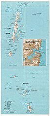
English: Map of the Nicobar and Andaman Islands. |
| Күні | |
| Көзі | Courtesy of the University of Texas Libraries, The University of Texas at Austin. Reproduced from the Perry-Castañeda Library Map Collection of the University of Texas, Austin; originally from The Indian Ocean Atlas, produced and published (1976) by the U.S. Central Intelligence Agency. |
| Авторы | Pyramide~commonswiki |
| Рұқсат (Бұл файлды қайта қолдану) |
This material is in the public domain according to notes at Indian Ocean Maps and The UT Library Web Material Usage Statement |

|
File:Map of Nicobar and Andaman Islands-en.svg is a vector version of this file. It should be used in place of this JPG file when not inferior.
File:Andaman nicobar 76.jpg → File:Map of Nicobar and Andaman Islands-en.svg
For more information, see Help:SVG. |
 |
Лицензиялау
| This image is a work of a Central Intelligence Agency employee, taken or made as part of that person's official duties. As a Work of the United States Government, this image or media is in the public domain in the United States.
|

|
Файл тарихы
Файл сол кезде қалай көрінгенін көру үшін күн/уақыт дегенге басыңыз.
| Күн/Уақыт | Нобай | Өлшемдер | Қатысушы | Пікір | |
|---|---|---|---|---|---|
| қазіргі | 02:00, 2004 ж. желтоқсанның 27 | | 894 × 2068 (315 КБ) | Pyramide~commonswiki | Taken from that map site of Texas University and it says that CIA made it. It qualifies to teh rules stated at http://www.lib.utexas.edu/usage_statement.html |
Файл қолданылуы
Бұл файлды мына бет қолданады:
Глобалды файл қолданылуы
Бұл файл келесі басқа уикилерде қолданылады:
- ar.wikipedia.org жобасында қолданылуы
- ast.wikipedia.org жобасында қолданылуы
- bcl.wikipedia.org жобасында қолданылуы
- bg.wikipedia.org жобасында қолданылуы
- bn.wikipedia.org жобасында қолданылуы
- bn.wikiquote.org жобасында қолданылуы
- ca.wikipedia.org жобасында қолданылуы
- da.wikipedia.org жобасында қолданылуы
- de.wikipedia.org жобасында қолданылуы
- de.wikivoyage.org жобасында қолданылуы
- en.wikipedia.org жобасында қолданылуы
- eo.wikipedia.org жобасында қолданылуы
- es.wikipedia.org жобасында қолданылуы
- eu.wikipedia.org жобасында қолданылуы
- fa.wikipedia.org жобасында қолданылуы
- fi.wikipedia.org жобасында қолданылуы
- fr.wikipedia.org жобасында қолданылуы
- ga.wikipedia.org жобасында қолданылуы
- hif.wikipedia.org жобасында қолданылуы
- hu.wikipedia.org жобасында қолданылуы
- id.wikipedia.org жобасында қолданылуы
- incubator.wikimedia.org жобасында қолданылуы
- ja.wikipedia.org жобасында қолданылуы
- jv.wikipedia.org жобасында қолданылуы
- kn.wikipedia.org жобасында қолданылуы
- ko.wikipedia.org жобасында қолданылуы
- la.wikipedia.org жобасында қолданылуы
- lt.wikipedia.org жобасында қолданылуы
- mk.wikipedia.org жобасында қолданылуы
- ml.wikipedia.org жобасында қолданылуы
Бұл файлдың глобалды қолданылуын көбірек көру.