Сурет:Bairisches Mundartgebiet.PNG
Бұл алдын ала көрудің өлшемі: 800 × 505 пиксел. Басқа ажыратылымдықтар: 320 × 202 пиксел | 640 × 404 пиксел | 1031 × 651 пиксел.
Түпнұсқа файл (1031 × 651 пиксел, файл өлшемі: 43 КБ, MIME түрі: image/png)
| Бұл файл Wikimedia Commons? жобасынан, сондықтан басқа жобаларда да қолдануы мүмкін. Commons ашық лицензиялы медиа файл қоры. Сіз жобаға көмектесе аласыз. |
Ортаққордан қарау |

|
This linguistic map image could be re-created using vector graphics as an SVG file. This has several advantages; see Commons:Media for cleanup for more information. If an SVG form of this image is available, please upload it and afterwards replace this template with
{{vector version available|new image name}}.
It is recommended to name the SVG file “Bairisches Mundartgebiet.svg”—then the template Vector version available (or Vva) does not need the new image name parameter. |
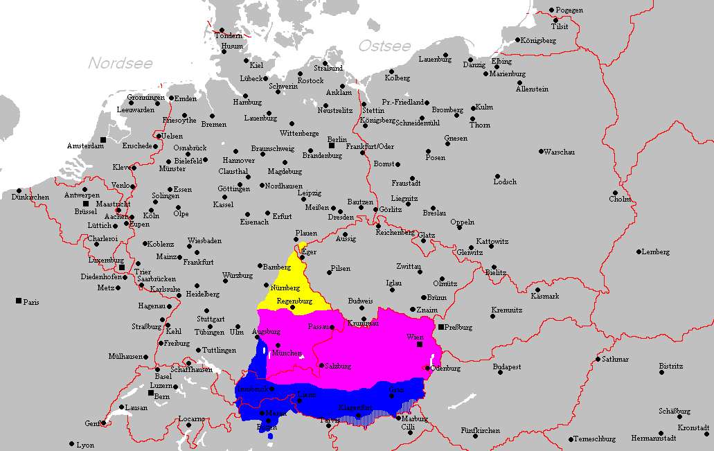
Түйін
العربية (ar): انتشار اللهجات البافارية الحديثة:
البافارية الشمالية (البالانتية العليا).
البافارية الوسطى (البافارية الدانوبية).
البافارية الجنوبية (البافارية الألبية).
Deutsch (de): Verbreitungsgebiet der heutigen bairischen Mundarten
Nordbairisch
Mittel- oder Donaubairisch
Südbairisch
English (en): Prevalence of modern Bavarian dialects
North Bavarian
Central or Danube Bavarian
South Bavarian
русский (ru): Современные ареалы распространения баварских диалектов
жёлтый: северо-баварский
розовый: среднебаварский (австро (дунайско)-баварский)
синий: южно-баварский
español (es): Distribución del Bavariano.
Baviera del Norte
Baviera central o del Danubio
Baviera del Sur
- design by: Postmann Michael
- Quelle: Selbst erstellt.
- Hinweis: Nach den Vorgaben des "Der Fischer-Informationsatlas der Bundesrepublik Deutschland" (ISBN 3-596-24556-4 Invalid ISBN) von 1990 (S. 63) selbst erstellt. Es wurde sowohl die Karte Westmitteleuropas als auch das bayrische Sprachgebiet vom Autor händisch erstellt. Diese Karte ist gemeinfrei und darf von jedermann verwendet werden!
- Source: Self-made.
- Notes: Information derived from "The Fischer Information Atlas of the Federal Republic of Germany" (ISBN 3-596-24556-4 Invalid ISBN) from 1990 (P. 63). Both the map of west Central Europe and the Bavarian language area were by hand provided by the author. This map is in the public domain and may be used by everyone!
Лицензиялау
| This work has been released into the public domain by its author, Postmann Michael. This applies worldwide. In some countries this may not be legally possible; if so: |
Файл тарихы
Файл сол кезде қалай көрінгенін көру үшін күн/уақыт дегенге басыңыз.
| Күн/Уақыт | Нобай | Өлшемдер | Қатысушы | Пікір | |
|---|---|---|---|---|---|
| қазіргі | 02:22, 2012 ж. ақпанның 19 | | 1031 × 651 (43 КБ) | Buachamer | Sechsämterland und Südvogtland hinzugefügt (siehe http://bar.wikipedia.org/wiki/Datei:Bairischer_Sprachraum2.PNG) |
| 22:56, 2009 ж. сәуірдің 12 |  | 1031 × 651 (57 КБ) | Altaileopard | Nürnberg aus dem bayerischen Dialektraum entfernt. | |
| 09:10, 2006 ж. наурыздың 2 |  | 1031 × 651 (57 КБ) | Postmann Michael~commonswiki |
Файл қолданылуы
Бұл файлды мына бет қолданады:
Глобалды файл қолданылуы
Бұл файл келесі басқа уикилерде қолданылады:
- als.wikipedia.org жобасында қолданылуы
- ar.wikipedia.org жобасында қолданылуы
- ast.wikipedia.org жобасында қолданылуы
- be-tarask.wikipedia.org жобасында қолданылуы
- be.wikipedia.org жобасында қолданылуы
- bg.wikipedia.org жобасында қолданылуы
- br.wikipedia.org жобасында қолданылуы
- ca.wikipedia.org жобасында қолданылуы
- cs.wikipedia.org жобасында қолданылуы
- da.wikipedia.org жобасында қолданылуы
- de.wikipedia.org жобасында қолданылуы
- de.wiktionary.org жобасында қолданылуы
- en.wikipedia.org жобасында қолданылуы
- es.wikipedia.org жобасында қолданылуы
- et.wikipedia.org жобасында қолданылуы
- eu.wikipedia.org жобасында қолданылуы
- fa.wikipedia.org жобасында қолданылуы
- fr.wikipedia.org жобасында қолданылуы
- fy.wikipedia.org жобасында қолданылуы
- ga.wikipedia.org жобасында қолданылуы
- hak.wikipedia.org жобасында қолданылуы
- he.wikipedia.org жобасында қолданылуы
- id.wikipedia.org жобасында қолданылуы
- incubator.wikimedia.org жобасында қолданылуы
- it.wikipedia.org жобасында қолданылуы
Бұл файлдың глобалды қолданылуын көбірек көру.