Сурет:Great Bitter Lake, Egypt.jpg

Бұл алдын ала көрудің өлшемі: 800 × 533 пиксел. Басқа ажыратылымдықтар: 320 × 213 пиксел | 640 × 427 пиксел | 1024 × 683 пиксел | 1440 × 960 пиксел.
Түпнұсқа файл (1440 × 960 пиксел, файл өлшемі: 323 КБ, MIME түрі: image/jpeg)
| Бұл файл Wikimedia Commons? жобасынан, сондықтан басқа жобаларда да қолдануы мүмкін. Commons ашық лицензиялы медиа файл қоры. Сіз жобаға көмектесе аласыз. |
Ортаққордан қарау |
Түйін
| Сипаттамасы |
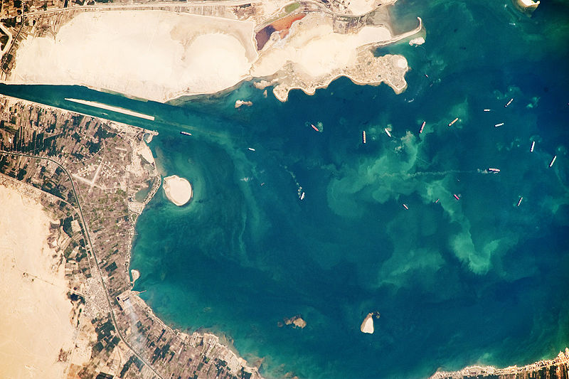
English: Several ships, some under power and some anchored, are visible at image right. Large expanses of white and tan sandy sediments at image left and top attest to the desert conditions surrounding the lake. Located at the approximate midpoint of the Suez Canal, Great Bitter Lake is now filled with water derived from both the Red and Mediterranean Seas, and this steady influx of water balances the water lost to evaporation. The town of Fayid (also spelled as Fayed), visible along the western shore of the lake (bottom) is a tourist destination for residents of Cairo, particularly in the summer months.
|
||||||||||||||||||||||||||||||||||||||||||||||||||
| Күні | |||||||||||||||||||||||||||||||||||||||||||||||||||
| Көзі | NASA Earth Observatory | ||||||||||||||||||||||||||||||||||||||||||||||||||
| Авторы | This image was taken by the NASA Expedition 20 crew. | ||||||||||||||||||||||||||||||||||||||||||||||||||
This photograph was acquired with a Nikon D3 digital camera fitted with an 800 mm lens, and is provided by the ISS Crew Earth Observations experiment and Image Science & Analysis Laboratory, Johnson Space Centre.
Лицензиялау
| This file is in the public domain in the United States because it was solely created by NASA. NASA copyright policy states that "NASA material is not protected by copyright unless noted". (See Template:PD-USGov, NASA copyright policy page or JPL Image Use Policy.) | ||
 |
Warnings:
|
Файл тарихы
Файл сол кезде қалай көрінгенін көру үшін күн/уақыт дегенге басыңыз.
| Күн/Уақыт | Нобай | Өлшемдер | Қатысушы | Пікір | |
|---|---|---|---|---|---|
| қазіргі | 20:23, 2009 ж. қазанның 26 | | 1440 × 960 (323 КБ) | Originalwana | {{Information |Description={{en|1=Several ships, some under power and some anchored, are visible at image right. Large expanses of white and tan sandy sediments at image left and top attest to the desert cond |
Файл қолданылуы
Бұл файлды мына бет қолданады:
Глобалды файл қолданылуы
Бұл файл келесі басқа уикилерде қолданылады:
- af.wikipedia.org жобасында қолданылуы
- ar.wikipedia.org жобасында қолданылуы
- arz.wikipedia.org жобасында қолданылуы
- ca.wikipedia.org жобасында қолданылуы
- en.wikipedia.org жобасында қолданылуы
- eo.wikipedia.org жобасында қолданылуы
- es.wikipedia.org жобасында қолданылуы
- eu.wikipedia.org жобасында қолданылуы
- fi.wikipedia.org жобасында қолданылуы
- he.wikipedia.org жобасында қолданылуы
- id.wikipedia.org жобасында қолданылуы
- la.wikipedia.org жобасында қолданылуы
- mt.wikipedia.org жобасында қолданылуы
- my.wikipedia.org жобасында қолданылуы
- pl.wikipedia.org жобасында қолданылуы
- pt.wikipedia.org жобасында қолданылуы
- simple.wikipedia.org жобасында қолданылуы
- tr.wikipedia.org жобасында қолданылуы
- zh.wikipedia.org жобасында қолданылуы